
Utah Hang Gliding & Paragliding Association
Grandeur
Wasatch National Forest

Millcreek, Utah
Revised 01 Jan 2026
Location
Elev 6308' / 1922m
Ratings & Skills
UPSHPA H3/P3 (H2/P2 w/instr)
High Altitude, Foot Launch
Restricted Landing Field
Radio Comm
Primary . . . . . . . . 146.560
Emergency . . . . . . 146.560
Access
2WD on paved public roads to the parking lot, then a steep one-mile hike up well-marked (north launches) or semi-marked (south launch) trails.
Known Hazards
MIdday thermic turbulence and strong, shifting upper level winds. Pilots tracking thermals off to the side or back behind launch have found themselves unable to glide back out front without encountering rotor. Long, steep hike to launch. Mini-wings note required glide ratio.
Site Sensitivites
Austere launch site with no emergency services. Access trails and launch sites situated on both National Forest land and private property. The restricted LZ is on public school grounds. Do not use the Eastwood Elementary LZ during normal school hours or when otherwise occupied (eg., during youth sports). Law enforcement response and loss of site access may result.
Attention All Users:
-
Grandeur is a challenging, high-altitude mountain-thermal site.
-
USHPA and UHGPGA membership required.
-
USHPA P3 rating required, (P2 under direct supervision of a USHPA-certified instructor or observer.)
-
Visiting and first-time users should obtain a detailed in-person pre-flight briefing from a local UHGPGA member-pilot with recent flying experience at this site. This briefing should take place at the launch site on the day of the flight. Pilots should pay close attention to the known hazards and site sensitivities described in this guide.
-
As pilot-in-command, you alone are responsible for assessing your fitness for flight, the airworthiness of your glider and equipment, the suitability of the current conditions for launch and recovery, and for continuously monitoring glider position and performance to ensure a safe landing at an approved landing zone. If in doubt, do not launch.

Trail Conditions
Grandeur is a hike-and-fly site. The distance from the trailhead to the North and Upper North Launches is a little over a mile, with a 1300-foot elevation gain. About a third of a mile up the trail you'll find the lower branch trail to the South Launch. On either trail you will be climbing a steep path in open, brushy terrain. The Great Basin rattlesnake, a protected species in Utah, is a common sight along the Grandeur Peak Trail, especially during the spring and fall (our best flying seasons) when he is active during daylight hours. Watch your footing and give any rattlers you encounter a wide berth. Be familiar with First Aid for a snake bite.
The Setup
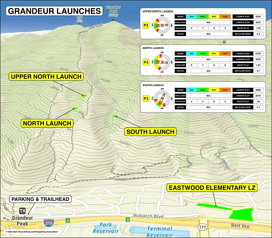
The North and Upper North Launches are along the trail on the spine of the ridgeline leading up to Grandeur Peak. The grade levels somewhat and you'll come to a wide flat spot just past a trail fork leading south. This is the North Launch. If you continue to climb the trail another 300 yards, you'll reach the Upper North Launch. Both launch areas offer plenty of room to set up and select a takeoff spot. The North Launch is the easier of the two and works well with northwest to southwest wind. Chances of climbing out from the North Launch are about 50/50. The Upper North Launch is steeper and rockier but affords an 80% chance of climbing out during the right conditions.
The South Launch works better with a south to southwest wind, and is more directly aligned with the LZ. All launches are rated P3, or P2 with an instructor. Midday thermic turbulence is common and should be avoided by P2 pilots.
Winds:
Upper North Launch
P3: Min = 5 mph, Ideal = 6-8 mph, Max = 9 mph, Gust 5 mph
Wind Direction: WNW - WSW
North Launch
P3: Min = 0 mph, Ideal = 5-8 mph, Max = 9 mph, Gust 6 mph
Wind Direction: NW - SW
South Launch
P3: Min = 2 mph, Ideal = 5-7 mph, Max = 9 mph, Gust 5 mph
Wind Direction: W - SW
The Landing Zone
Reaching the LZ requires overflight of a dense suburban neighborhood. There are trees, fences, and other obstacles boarding it. The LZ consists of playing fields at Eastwood Elementary School, and for this reason the site is not available during normal school hours. Children may be present in the LZ at any time. After school and weekends, it is common for all useable landing fields to be occupied by youth sports leagues, and law enforcement has in the past responded to complaints of glider pilots interrupting games.
Scout this LZ before launch. Be in phone or radio contact with a spotter at the LZ, and do not launch if you cannot maintain adequate separation from bystanders when you land. "Adequate separation" means no one has to pause or alter their activities to accommodate your arrival!
The longer, narrower upper LZ is on the east side of the school building with a steep embankment on its eastern perimeter. The square lower LZ is south of the school building. There are no wires bordering the school, but both fields have fixed playground structures plainly visible. All landing surfaces are level, well-drained turf.

Special Considerations
Park and begin your hike from the Grandeur Peak Trailhead parking lot at 2900 Wasatch Blvd. Many neighborhood streets have restricted parking, especially the cul de sac on Cascade Way. Some pilots will park on the street south of the elementary school, and hike up through the neighborhood from there.
The hike to all launches is primarily on Wasatch National Forest land. You will share the trail with other hikers. After landing, promptly pack and remove your glider. This site is noise- and traffic-sensitive. Our host is the Granite School District, and they appreciate your professional and considerate use of their property.
Please be aware that pilots who have departed the area of Grandeur have found it very difficult to find a friendly and familiar landing area outside of the designated one. It is a very populated area with obstacles all around. Pilots should successfully fly and spend time at the site before planning to fly XC from it, and consider how difficult it may be to return to the designated landing zone or find available landing options if leaving the area.