Utah Hang Gliding & Paragliding Association
Crawford's
Crawford Mountains (BLM)

Randolph, Utah
Revised 01 Jan 2026
Location
Elev 7682' / 2341m
Ratings & Skills
UPSHPA H2 / P2
High Altitude, Foot Launch
Radio Comm
Primary . . . . . . . . 146.560
Emergency . . . . . . 146.560
Access
4WD year round, chains req'd during the long snow season. Two-track dirt service road, wash-boarded in spots. Loose cattle present on the road day and night.
Known Hazards
Midday thermic turbulence. Rotors behind the ridge, do not attempt top landing. Winds above 15mph may require assisted launch. Pasture Gate LZ may be seasonally flooded for irrigation.
Site Sensitivites
Austere launch site with no emergency services. Launch is on BLM land, LZ's are on private ranch land. Very supportive landowner, return the favor by taking care of fences, gates and livestock. Limited room for retrieve vehicles along roadway next to Pasture Gate LZ. Do not park in pastures.
Attention All Users:
-
Crawford's (aka Randolph) is a challenging, high-altitude mountain-thermal site.
-
USHPA and UHGPGA membership required.
-
USHPA P2 / H2 rating required, unless under direct supervision of a USHPA certified instructor or observer.
-
Visiting and first-time pilots should obtain a detailed in-person pre-flight briefing from a local UHGPGA member-pilot with recent flying experience at this site. This briefing should take place at the launch site on the day of the flight. Pilots should familiarize themselves with the known hazards and site sensitivities described in this guide.
-
As pilot-in-command, you alone are responsible for assessing your fitness for flight, the airworthiness of your glider and equipment, the suitability of the current conditions for launch and recovery, and for continuously monitoring glider position and performance to ensure a safe landing at an approved landing zone. If in doubt, do not launch.

Road Conditions:
The road to the launch site is open year-round, but likely impassable during snow season. 4WD or chains or both required if snowy or wet. The canyon road appears accessible to 2WD passenger cars but the steep turnoff and climb at the 3-mile point, characterized by deep ruts and sharp rocks, will damage 4-ply passenger tires. Cattle range freely on the road at all hours. Black cows are especially hard to see at night, so slow down and use extra caution when on this road after sunset.
Google Maps will not take you all the way to Crawford's Launch. Directions will end at the 3-mile point, at a lefthand bend in the wide dirt road. At that point look to the right and follow a rocky uphill trail towards the north. This leads up to the ridgeline and the launch site. Pass the large rectangular radio reflectors on your left. Further up the trail, a grouping of small juniper trees ahead marks the launch site.
The Setup:
If it’s windy you can set up in the protected lee of the cedar bushes, or tie off to the downwind side of your vehicle. Even in a stiff breeze there is a pocket of still air behind the ridge, suggesting rotors up above. (Don’t fly back there after launch.) A west to slightly northwest wind works best. On good days, pilots arrive in the early afternoon, set up, and wait for the wind to come up; on breezy days, you’ll be waiting for the wind to die down. Use extreme caution when the wind is fresh from the southwest. Have assistants walk with you as you leave the sheltered setup area and cross the road to move into launch position.
With any appreciable breeze at all, gusts can be surprisingly strong at the launch and upsets are common. Wire assists are strongly recommended!
Prepare for a strong burble immediately after launch due to irregular airflow over the palisades directly below you. Punch through this into the smooth air beyond. Ridge lift can immediately take you 2,000 to 3,000 feet or more above launch. The ridgeline, which runs nearly due north and south, is 6 miles long. Lift abates near the ridge's far southern end where the cliffs face southeast, and return flight back to the LZ may be impossible.
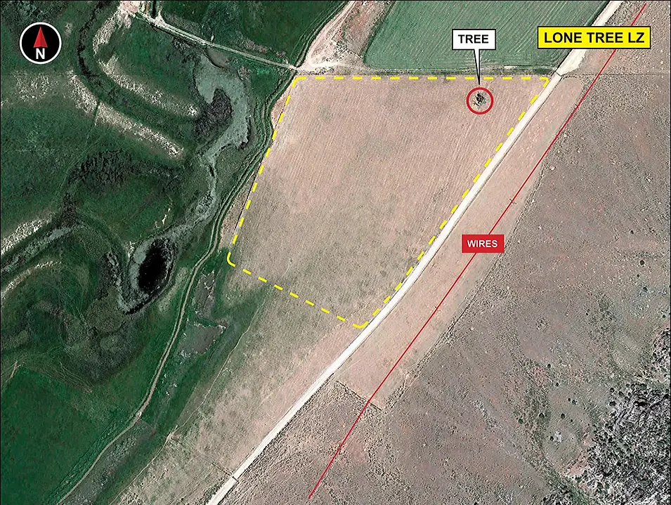
The Landing Zones:
The valley floor offers hundreds of acres of wide open safe landing spots, but the Pasture Gate LZ you passed on your drive in (and where someone normally places a temporary windsock) is the preferred area to end the flight. Everything you see below you is private ranch land with active haying and grazing operations. River flooding is used to irrigate this land in the spring and early summer, during which time the surface will vary from soft and muddy to standing water. The slightly higher patch of ground near the gate dries out first, and stays dry and firm. If there is any water outside the creek channels, have bug spray on hand; the mosquitoes in the LZ can be brutal. By late summer, most surfaces will be dry, flat, closely-mowed hayfields.

The Lone Tree LZ is almost directly below launch, and serves as a safe bailout landing spot if you sink out to the south. Otherwise, even in zero-lift, no-wind conditions, wings with a glide ratio of at least 7.4 to 1 can traverse the 1.6 miles direct to the Pasture Gate LZ with altitude to spare. After flying the sunset glass-off, expect significant wind gradient approaching the valley floor, with pockets of mild cool-air turbulence in the descent. Shadows on the cliff face below you cast by the lowering sun are a precursor to downslope winds, which you should account for in your approach and landing setup. Keep an eye on the windsock and the gliders landing ahead of you.
Note: If you are leaving a vehicle at the LZ prior to proceeding to launch, DO NOT PARK on the north side of the road. Doing so prevents the landowner from moving cattle from pasture to pasture along the road. Park all retrieve vehicles (including dirt bikes, ATVs, etc.) off the road on the SOUTH SIDE along the fence immediately adjacent to the LZ.
Our hosts are family farmers and ranchers who support our use of their property and make Crawford's flyable. They will appreciate your professional and courteous conduct on their land. After landing, disassemble or fold your glider and promptly exit the LZ. Don’t climb the fences—find a gate, and leave all gates as you found them. Give livestock a wide berth, especially when driving back to the summit after dark.
Exercise extreme caution when driving on any of the ranch roads! Pilots report being greeted by the ranch owner's friendly dogs while retrieving from the Lone Tree LZ. Be on the lookout for dogs and cattle on the road.